文章信息
- 李青生, 王翠, 蒋金龙, 黄金良, 吴耀建. 2020.
- LI Qing-sheng, WANG Cui, JIANG Jin-long, HUANG Jin-liang, WU Yao-jian. 2020.
- 九龙江口表层沉积物重金属的污染特征与来源分析
- Pollution characteristics and source apportionment of heavy metals in the surface sediments of the Jiulong River Estuary
- 海洋科学, 44(12): 32-43
- Marine Sciences, 44(12): 32-43.
- http://dx.doi.org/10.11759/hykx20200219001
-
文章历史
- 收稿日期:2020-02-19
- 修回日期:2020-06-28
2. 自然资源部 第三海洋研究所, 福建省海洋生态保护与修复重点实验室, 福建 厦门 361005;
3. 厦门大学 福建省海岸带污染防控重点实验室, 福建 厦门 361102
2. Third Institute of Oceanography, Ministry of Natural Resources, Fujian Provincial Key Laboratory of Marine Ecological Conservation and Restoration, Xiamen 361005, China;
3. Xiamen University, Fujian Key Laboratory of Coastal Pollution Prevention and Control, Xiamen 361102, China
重金属因为其毒性、持久性和生物累积性已经成为世界性的环境问题[1-3]。作为陆地和海洋强烈作用区域, 河口是陆源污染的蓄积池; 同时大部分河口区域经济发达, 河口区域的人类活动也是河口污染物的重要来源[4-6]。沉积物重金属可能因环境条件的变化再次释放, 从而造成水环境的二次污染, 沉积物重金属是河口生态系统健康的重要压力来源[7-12]。因此进行河口沉积物重金属污染特征研究很有必要, 也是进行沉积物重金属污染控制与环境管理的基础。
近年来, 河口沉积物重金属污染方面的研究逐渐成为研究热点[13-15], 以往的研究主要集中在时空分布[5-7]、累积性风险分析[16-21]、源解析[22-28]等方面, 但是对于河口重金属的分区、污染贡献的流域与河口比较等方面的研究, 仍然相对很少。另外, 以往的研究在沉积物重金属污染特征分析的基础上, 很少提出相应的污染控制与生态修复建议, 而相关建议是污染分析的成果, 也是重金属污染控制的基础。
九龙江位于福建闽南沿海发达地区, 是福建省第二大河, 流经农业发达的漳州平原, 作为漳州、龙岩、厦门3地超过500万人的饮用水与工农业用水源, 其区域的生态意义重大。近年来, 快速发展的工业化和城镇化已经影响了流域和河口的环境质量[29]。研究河口沉积物重金属的污染特征及其影响因素对于九龙江流域与河口的环境污染控制与管理具有重要的现实意义。鉴于此, 作者系统地分析了九龙江口沉积物重金属空间分布、污染分区、累积特征及来源、流域和河口人类活动对河口沉积物的影响, 提出了相应的管理建议, 以期为九龙江口沉积物污染控制、规划与管理提供技术支撑。
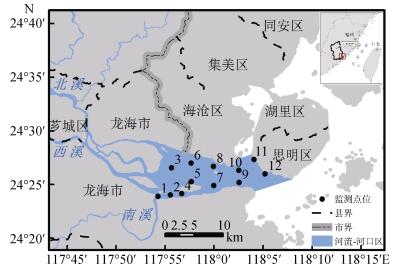
1 研究区域、数据与方法 1.1 研究区域九龙江发源于龙岩市新罗区和漳州市南靖县, 由北溪、西溪和南溪组成, 向东南汇入厦门湾, 河口区位于龙海市东部海域和厦门市西部海域(图 1)。九龙江流域地质构造复杂, 燕山晚期侵入的黑云母花岗岩掩体分布最广泛, 火山喷出岩性多为凝灰熔岩、流纹岩、凝灰岩等。上游出露部分古生界、中生界沉积岩地层, 下游平原多分布第四纪沉积地层。上游地区主要为山地、丘陵, 下游主要为平原。多年平均气温19.9~21.1℃, 多年平均降雨量1 400~ 1 800 mm。北溪多年平均流量281.4 m3/s, 年平均径流量8.230×10⁹ m3; 西溪多年平均流量117 m3/s, 年平均径流量3.68×10⁹ m3。上游河谷区域有较多的农业和采矿活动; 下游为漳州平原, 农业集约化程度高; 近年来, 下游地区工业也发展较快。九龙江口分布于流域东南部, 经、纬度范围为117°46′30″E~ 118°5′30″E、24°22′00″N~24°29′30″N。九龙江口常年水温在13~32℃变动, 为典型的亚热带沉溺型河口, 河口潮汐是常规半日潮, 河口岛屿胡茂洲、吴娇洲和玉枕洲将河口分为北支、中支和南支。河口区分布着红树林、白鹭自然保护区等, 滨海湿地面积较大; 河口区养殖业发达, 周边陆域主要为池塘养殖, 水域主要为网箱养殖, 河口周边分布着较多工业企业。
 |
| 图 1 研究区域地理位置 Fig. 1 Location of the study area |
自然资源部第三海洋研究所在九龙江口针对南北河道入海口布设了12个采样点采集沉积物表层样(图 1), 采样时间为2013年9月。表层沉积物采样深度为2 cm以浅, 九龙江口沉积速率约为0.43 cm/a, 采集样品反映的时间尺度为4 a~5 a。采样时用干净的塑料勺采集表层沉积物湿样, 装于磨口玻璃瓶中, 每份样品量湿质量约200 g左右, 冷藏保存, 供后续分析使用。分析了Cu、Pb、Zn、Cd、Cr、Hg、As、硫化物、总有机碳和石油类含量等10个指标, 其中Cu和Zn含量采用火焰原子吸收分光光度法测定, Pb、Cr和Cd含量采用无火焰原子吸收分光光度法测定, Hg和As含量采用原子荧光法测定, 油类含量采用荧光分光光度法测定, 有机碳含量采用重铬酸钾氧化还原容量法测定, 硫化物采用碘量法测定。样品采集、储存和运输方法及分析方法均严格按照GB 17378.5-2007《海洋监测规范第5部分:沉积物分析》[30]的有关要求进行, 沉积物相关指标如表 1所示。
| 站位 | Cu | Pb | Zn | Cd | Cr | Hg | As | 硫化物 | 有机碳 | 油类 |
| 1 | 42.21 | 82.20 | 223.05 | 0.47 | 107.04 | 0.05 | 6.90 | 471.90 | 0.59 | 31.00 |
| 2 | 32.69 | 39.42 | 186.00 | 0.42 | 82.80 | 0.04 | 7.50 | 255.90 | 0.68 | 36.00 |
| 3 | 10.01 | 32.28 | 83.55 | 0.16 | 29.04 | 0.07 | 10.20 | 17.10 | 0.45 | 26.00 |
| 4 | 4.90 | 32.40 | 53.55 | 0.07 | 5.76 | 0.08 | 11.00 | 13.80 | 0.03 | 32.50 |
| 5 | 23.70 | 76.62 | 121.05 | 0.43 | 20.00 | 0.06 | 7.90 | 117.00 | 0.61 | 36.00 |
| 6 | 8.86 | 47.22 | 91.05 | 0.19 | 12.24 | 0.08 | 9.50 | 48.30 | 0.24 | 21.00 |
| 7 | 33.99 | 60.18 | 172.05 | 0.47 | 31.28 | 0.09 | 10.30 | 795.00 | 1.14 | 18.00 |
| 8 | 23.00 | 36.00 | 126.00 | 0.20 | 39.44 | 0.06 | 10.50 | 137.10 | 0.88 | 25.00 |
| 9 | 21.32 | 46.20 | 120.00 | 0.18 | 47.84 | 0.07 | 8.10 | 140.10 | 1.20 | 24.00 |
| 10 | 24.40 | 26.52 | 127.95 | 0.11 | 92.72 | 0.08 | 8.00 | 47.10 | 0.95 | 39.00 |
| 11 | 15.89 | 30.30 | 99.45 | 0.12 | 70.72 | 0.13 | 9.20 | 68.40 | 0.77 | 63.00 |
| 12 | 19.29 | 19.50 | 96.90 | 0.12 | 59.20 | 0.14 | 8.40 | 88.80 | 0.68 | 69.50 |
| 平均值 | 21.69 | 44.07 | 125.05 | 0.25 | 49.84 | 0.08 | 8.96 | 183.38 | 0.69 | 35.08 |
| 标准差 | 10.99 | 19.66 | 47.69 | 0.16 | 32.83 | 0.03 | 1.34 | 230.89 | 0.34 | 15.96 |
| 中位值 | 22.16 | 37.71 | 120.53 | 0.19 | 43.64 | 0.07 | 8.80 | 102.90 | 0.68 | 31.75 |
本研究中GIS分析内容主要包括沉积物重金属含量的空间插值、流域边界划定以及流域土地利用分析。
利用反距离权重法(Inverse Distance Weight, IDW)进行空间插值, 基于各站位采样获得的沉积物重金属含量数据生成沉积物重金属含量空间分布栅格图(栅格边长30 m), 以分析沉积物重金属的空间分布特征。基于已有的研究结果[29], 利用GIS的水文模拟功能, 界定了流域的边界, 根据河流走向确定了北溪、西溪和南溪的流域边界。基于2016年Landsat TM遥感影像数解译得到的土地利用类型图, 获得了农业用地、林地、园地、水体、城镇建设用地和未利用地6类, 利用GIS进一步提取了北溪、西溪、南溪以及河口岸线1 km缓冲区的土地利用信息。
1.4 统计分析 1.4.1 层次聚类分析聚类分析根据观测对象之间的相似程度逐次聚合, 达到“物以类聚”的目的, 其中层次聚类分析(Hierarchical Clustering Analysis, HCA)方法的应用最为广泛[31]。本研究中采用离差平方和法(Ward’s Method)和平方欧氏距离法(Squared Euclidean Distance)[32-33]分析九龙江口各站位沉积物污染特征的空间相似性和差异性。
1.4.2 线性相关分析本研究中采用线性相关分析方法, 分析河口沉积物重金属指标之间的相关性, 识别沉积物重金属来源的相似性与差异性。
1.4.3 主成分分析采用主成分分析法(Principal Component Analysis, PCA)分析重金属来源。PCA通过正交变换将一组可能存在相关性的变量转换为一组线性不相关的新变量, 新变量在反映课题的信息方面尽可能保持原有的信息[34]。
本研究利用Microsoft Excel 2010和SPSS Statistics 17.0进行统计分析。
1.5 地质累积系数评价地质累积系数法(Geoaccumulation Index, Igeo)是由Müller[35]提出的一种评价沉积物中重金属毒性的方法, 在河口沉积物重金属评价中被广泛应用[2, 16-17, 20]。它是将当前的重金属浓度与重金属的背景值进行比较。地质累积系数法的计算公式为:
其中, Cn是沉积物中重金属含量实测值, Bn是沉积物中重金属的背景值, 本研究采用福建省海岸带土壤环境背景值作为参比值[36], 1.5为背景矩阵校正因数。Muller[37]区分了7个Igeo级别, 从第零级(Igeo≤0)到第六级(Igeo > 5), 分别表示未污染(Igeo≤0)、未污染至中度污染(0≤Igeo≤1)、中度污染(1≤Igeo≤2)、中度至重度污染(2≤Igeo≤3)、重度污染(3≤Igeo≤4)、重度至极度污染(4≤Igeo≤5)和极度污染(Igeo≥5)。
2 结果与讨论 2.1 沉积物重金属空间分布九龙江口表层沉积物中的Cu、Pb、Zn、Cr、Cd、Hg和As含量分别为4.90~42.21 μg/g(平均值为21.69 μg/g, 图 2)、19.50~82.20 μg/g(平均值为44.07 μg/g)、53.55~223.05 μg/g(平均值为125.05 μg/g)、0.07~ 0.47 μg/g(平均值为0.25 μg/g)、5.76 ~107.04 μg/g(平均值为49.84 μg/g)、0.04~0.14 μg/g(平均值为0.08 μg/g)和6.90~11.00 μg/g (平均值为8.96 μg/g)。
 |
| 图 2 九龙江口海域重金属空间分布(μg/g) Fig. 2 Spatial variation of heavy metals in the surface sediment of JRE(μg/g) |
Cu、Pb、Zn和Cd的空间分布相似性较高, 高值区均分布在南溪入海口和海门岛附近海域, Cr含量的高值区分布在南溪口附近海域及鼓浪屿附近海域。Hg和As的高值区与前述重金属有所不同。
将九龙江口表层沉积物重金属含量与中国其他河口或河口湾进行了比较, 结果如表 2所示。九龙江河口表层沉积物重金属含量低于泉州湾、汕头湾和厦门西海域, 但高于环渤海周边河口海域(黄河口、辽河口和双台子河口)、拓林湾。九龙江河口表层沉积物中的Cu和Cr的浓度低于长江口和珠江口, 而Zn的浓度高于长江口和珠江口。说明九龙江口表层沉积物含量整体要低于一些经济发达地区河口表层沉积物重金属含量(泉州湾、汕头湾等), 而要高于一些开发程度相对较低地区的河口(黄河口、辽河口和双台子河口等), 经济发展水平越高、发展规模越大, 排放的污染物就越多, 对河口水体、沉积物的影响也相对较大。另外, 环渤海周边河口海域(黄河口、辽河口和双台子河口)的重金属含量较低可能也跟区域的重金属背景值较低有关。
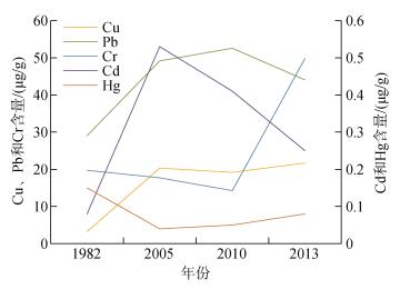
将本次表层沉积物重金属含量与本区域历史研究成果进行了比较, 鉴于Zn和As的历史资料不全, 本研究只选取了Cu、Pb、Cd、Cr和Hg进行了比较, 如表 2和图 3所示。Cu整体呈上升趋势, Pb、Cd呈先上升后下降趋势, Cr和Hg呈先下降后上升的趋势。这可能跟20世纪80年代以来九龙江流域经济发展有关, 经济的迅速发展带来的污染物排放也逐渐增加, 但是近年来随着环境保护工作的加强, 环境质量有逐渐改善的趋势, 使得污染物变化趋势发生变化。
| 研究区域 | Cu | Pb | Zn | Cd | Cr | Hg | As | 参考文献 |
| 九龙江口(1982年) | 3.22 | 29.04 | 11.82 | 0.08 | 19.73 | 0.15 | — | — |
| 九龙江口(2005年) | 20.32 | 49.15 | — | 0.53 | 17.70 | 0.04 | 6.83 | — |
| 九龙江口(2010年) | 19.17 | 52.57 | 146.06 | 0.41 | 14.25 | 0.05 | 3.31 | — |
| 九龙江口(本研究) | 21.69 | 44.07 | 125.05 | 0.25 | 49.84 | 0.08 | 8.96 | 本研究 |
| 厦门西海域 | 44.00 | 50.00 | 139.00 | 0.33 | 75.00 | — | — | [18] |
| 泉州湾 | 71.40 | 67.70 | 179.60 | 0.59 | 82.00 | 0.40 | 21.00 | [13] |
| 珠江口 | 39.00 | 59.40 | 111.00 | 0.34 | 56.00 | 1.40 | — | [38] |
| 黄河口 | 16.50 | 16.00 | 21.00 | — | 17.40 | 0.05 | 6.50 | [39] |
| 大辽河口 | 11.20 | 19.61 | 47.23 | 0.62 | 32.02 | — | 7.91 | [26] |
| 长江口 | 25.51 | 24.18 | 84.91 | 0.15 | 87.17 | 0.05 | 9.96 | [22] |
| 双台子河口 | 6.50 | 6.89 | 58.65 | 0.50 | — | 0.01 | — | [40] |
| 柘林湾(黄冈河口) | 11.90 | 41.70 | 67.80 | 0.05 | 20.20 | 0.05 | 5.47 | [41] |
| 汕头湾(韩江口) | 48.52 | 51.63 | 153.28 | 0.67 | 53.56 | — | — | [42] |
| 注: “—”空白表示无数据 | ||||||||
 |
| 图 3 本研究和本区域之前研究的沉积物重金属含量比较 Fig. 3 Comparison of heavy metal concentrations in this study with those of previous studies in JRE |
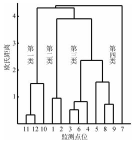
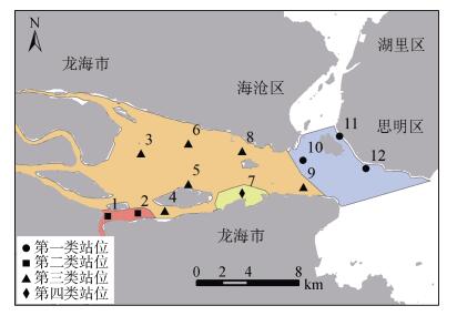
本研究根据各采样站点的沉积物污染物含量, 进行层次聚类分析, 在Wards距离为10处将采样点位分为4类(图 4), 各类别的空间分布如图 5所示。第一类主要分布在河口区外侧, 表层沉积物中油类含量较高, 此区域处于厦门西港航道集中区, 航运繁忙, 此区的沉积物受到厦门西港航运的影响; 第二类主要分布在南溪出海口, 表层沉积物中的硫化物、Zn、Cr的含量较高, 此区域受到北溪、西溪和南溪的共同影响, 特别是南溪流域工厂、池塘养殖较多, 排放污染物对沉积物影响较大; 第三类主要分布在河口区中北部, 表层沉积物中的污染物浓度处于中等水平; 第四类主要分布在九龙江口区东南部、海门岛下游海域, 硫化物、TOC、Cu、Pb和Zn含量较高, 此区域的开山采石、围填海活动较多, 修船厂也较多, 对海域沉积物的影响较大(表 3)。
 |
| 图 4 聚类分析结果图 Fig. 4 The result of cluster analysis |
 |
| 图 5 4类站位的空间分布图 Fig. 5 Four categories of monitoring station distribution |
| 参数 | 第一类 | 第二类 | 第三类 | 第四类 |
| 硫化物 | 68.10±20.85 | 363.90±152.74 | 78.90±59.29 | 795.00 |
| TOC | 0.80±0.14 | 0.64±0.06 | 0.57±0.43 | 1.14 |
| Cu | 19.86±4.28 | 37.45±6.73 | 15.30±8.29 | 33.99 |
| Pb | 25.44±5.48 | 60.81±30.25 | 45.12±16.78 | 60.18 |
| Zn | 108.10±17.24 | 204.53±26.20 | 99.20±28.37 | 172.05 |
| Cd | 0.12±0.01 | 0.45±0.04 | 0.21±0.12 | 0.47 |
| Cr | 74.21±17.03 | 94.92±17.14 | 25.72±16.13 | 31.28 |
| Hg | 0.12±0.03 | 0.04±0.01 | 0.07±0.01 | 0.09 |
| Zn | 8.53±0.61 | 7.20±0.42 | 9.53±1.28 | 10.30 |
| 油类 | 57.17±16.06 | 33.50±3.54 | 27.42±5.66 | 18.00 |
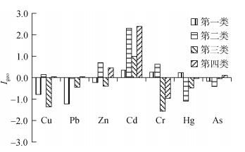
本研究中, Igeo指数被用于评估九龙江口表层沉积物中重金属的累积情况, 结果如图 6所示。Hg、Cu、Pb、Zn、Cr、As处于未污染到轻度污染水平, Cd为轻度污染到重度污染水平。7种重金属中, Zn、Cr、Cd的Igeo指数相对较高, 第二类和第四类站位的Igeo指数相对较高。
 |
| 图 6 4类站位中的Igeo指数变化 Fig. 6 Variation of Igeo index in four categories |
将表层沉积物污染物指标进行相关性分析, 结果如表 4所示。硫化物与Cu、Zn、Cd正相关性较高, Cu与Zn、Cd、Cr正相关性较高, Pb与Zn、Cd正相关性较高, Zn与Cd、Cr正相关性较高, Hg与石油类正相关性较高。相关性分析表明硫化物、Cu、Pb、Zn、Cd和Cr的来源相似, 而Hg与石油类的来源相似。
| 硫化物 | TOC | Cu | Pb | Zn | Cd | Cr | Hg | As | 石油类 | |
| 硫化物 | 1.00 | 0.45 | 0.76** | 0.57 | 0.75** | 0.78** | 0.20 | –0.13 | –0.09 | –0.34 |
| TOC | 0.45 | 1.00 | 0.56 | 0.06 | 0.45 | 0.22 | 0.39 | 0.07 | –0.27 | –0.03 |
| Cu | 0.76** | 0.56 | 1.00 | 0.58 | 0.97** | 0.79** | 0.674* | –0.35 | –0.62* | –0.10 |
| Pb | 0.57 | 0.06 | 0.58 | 1.00 | 0.61* | 0.83** | 0.03 | –0.49 | –0.37 | –0.45 |
| Zn | 0.75** | 0.45 | 0.97** | 0.61* | 1.00 | 0.82** | 0.67* | –0.45 | –0.61* | –0.21 |
| Cd | 0.77** | 0.22 | 0.79** | 0.83** | 0.82** | 1.00 | 0.20 | –0.49 | –0.41 | –0.35 |
| Cr | 0.20 | 0.39 | 0.67* | 0.03 | 0.67* | 0.20 | 1.00 | –0.05 | –0.73** | 0.37 |
| Hg | –0.13 | 0.07 | –0.35 | –0.49 | –0.45 | –0.49 | –0.05 | 1.00 | 0.23 | 0.72** |
| As | –0.09 | –0.27 | –0.62* | –0.37 | –0.61* | –0.41 | –0.73** | 0.23 | 1.00 | –0.27 |
| Oil | –0.34 | –0.03 | –0.10 | –0.45 | –0.21 | –0.35 | 0.37 | 0.72** | –0.27 | 1.00 |
| 注: “**”表示在0.01水平上显著相关; “*”表示在0.05水平上显著相关 | ||||||||||
利用最大方差旋转的主成分分析法对九龙江口表层沉积物污染物指标进行分析, 结果如表 5所示。主成分分析共提取了3个主成分(Principal Component, PC), 3个主成分可以解释84.83%的总方差。
| 指标 | PC1 | PC2 | PC3 |
| 硫化物 | 0.36 | 0.89 | –0.01 |
| TOC | –0.18 | 0.76 | 0.19 |
| Cu | 0.37 | 0.70 | 0.58 |
| Pb | 0.78 | 0.32 | 0.16 |
| Zn | 0.49 | 0.63 | 0.58 |
| Cd | 0.70 | 0.55 | 0.25 |
| Cr | –0.13 | 0.27 | 0.88 |
| Hg | –0.88 | 0.14 | –0.15 |
| As | –0.17 | –0.07 | –0.92 |
| 石油类 | –0.77 | –0.12 | 0.45 |
| 方差解释(%) | 30.61 | 27.67 | 26.55 |
| 累积方差解释(%) | 30.61 | 58.28 | 84.83 |
第一主成分解释了30.61%的总方差, 其中Pb、Cd占有较大的载荷; 相关分析表明: Pb、Zn、Cd之间的正相关性较高, 说明他们有着相似的来源; Cd的污染物累积水平处于为轻度污染到重度污染水平, 说明有人类活动的影响; 第一主成分代表了流域工农业活动和采矿活动带来的污染。
相关研究表明, Pb、Zn、Cd普遍存在于化肥和农药中[43-45], 九龙江流经农业发达的漳州平原, 农业污染对流域和河口的污染不容忽视, 而河口区的农业用地比例比流域的比例更高(图 7), 显示了河口区可能对沉积物重金属污染有更大的贡献; 九龙江下游各县区的工业总产值与企业数量比较也显示, 处于河口区的龙海市工业总产值最高、企业数量最多(表 6), 而河口区目前还未建工业污水处理厂, 企业未经处理或简单处理的污水排放会导致部分污染物进入河口沉积物; 另外, 福建地区广泛地分布着燕山期中、酸性岩浆岩, 岩石中Pb、Zn的克拉克值较高, 当岩石风化或经开采后, 其中所含的Pb、Zn将随其晶格的破坏而被地表径流搬运入海, 使得沉积物中的Pb、Zn含量较高[47]。
| 土地利用类型 | 土地利用面积比例(%) | ||
| 北溪和西溪流域 | 南溪流域 | 河口岸线1 km缓冲区 | |
| 耕地 | 7.59 | 14.20 | 39.48 |
| 林地 | 76.99 | 66.92 | 4.78 |
| 水体 | 0.97 | 2.49 | 4.30 |
| 建设用地 | 6.55 | 11.22 | 50.82 |
| 未利用地 | 0.07 | 0.01 | 0.00 |
| 果园 | 7.83 | 5.14 | 0.62 |
| 注:土地利用数据是通过Landsat TM遥感影像数解译获得 | |||
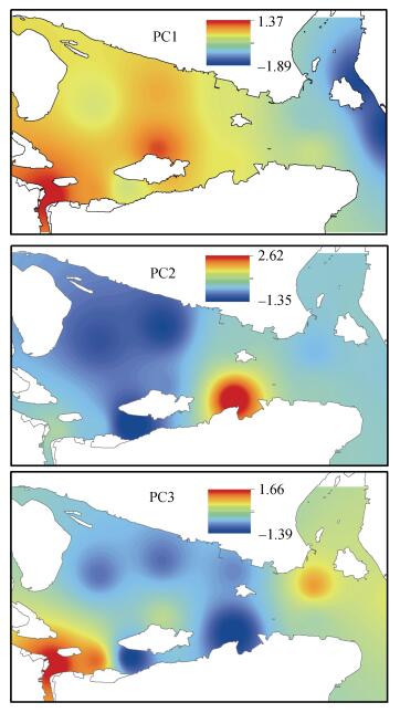
从前述分析可知:第二类的站位的Cd、Zn的Igeo指数相对较高, 说明第二类站位所在区域与第一主成分的相关性较大:第二类站位所在海域为九龙江口南岸、靠近南溪出海口的海域, 同时受到北溪、西溪和南溪的影响, 周边农业用地较多(表 6), 其沉积物是受到工农业活动影响的典型区域。主成分分布图(图 8)显示:第一主成分高值区主要分布在九龙江河口区南侧及南溪口附近, 这与上述分析整体上是一致的。
 |
| 图 8 各主成分空间分布 Fig. 8 Spatial distribution of PCs |
第二主成分解释了27.67%的总方差, 其中硫化物、TOC、Cu占有较大的载荷, 相关分析也表明, 硫化物、Cu、Zn、Cd之间存在着显著的正相关性, 说明他们有着相似的来源; Cu的污染物累积水平处于未污染到轻度污染水平。第二主成分代表水土流失的影响[48-50]。由图 8可知:第二主成分的高值区位于海门岛下游区域, 附近海岸分布着较多的码头、公路建设项目, 而当地山地较多, 沿岸建设项目多为挖山填海形成的, 导致水土流失较多, 进而影响河口海域沉积物。
第三主成分解释了26.55%的总方差, 其中Cr占有较大的载荷, Cr的污染物累积水平处于未污染到轻度污染水平, 且Cr与Cu、Zn呈正相关关系, 说明Cr与Cu、Zn的来源相似。第三主成分代表了自然风化的影响[16, 51]。由图 8可知:第三主成分的高值区位于九龙江河口区南侧、南溪口及厦门西海域鼓浪屿附近海域, 这跟流域、海域侵蚀有关。
2.4 污染控制与生态修复建议 2.4.1 农业污染控制九龙江流经福建省最大的平原——漳州平原, 流域农业非常发达, 但农业生产带来的面源污染也不容忽视, 对流域和河口的水质、沉积物都有很大的影响, 因此流域农业面源的控制对于河口沉积物质量具有重要意义。流域面源控制可采取以下措施: (1)减少化肥、农药的施用, 多用农家肥; (2)利用漳州平原河网密布、水源充足的特点, 发展生态农业, 把发展粮食与多种经济作物轮作生产、发展大田种植与林、牧、副、渔业生产结合起来, 实现丰富农产品数量和品质、减少农业面源污染等效益。
2.4.2 工业污染的控制工业污染是河口表层沉积物重金属的重要来源, 九龙江下游的漳州市企业较多, 尤其是位于河口区的龙海市, 其企业在漳州县区最多。因此控制流域和河口区的企业污染对环境管理十分必要。目前流域下游各县区的的污水处理厂较少、规模较小, 一般仅处理县区行政中心的生活污水, 处于郊区或者农村的企业污水一般都未经处理直接排放或经过简单处理排河, 对流域、河口的水质和沉积物造成较大影响。因此, 工业污染控制的关键是建设区域工业污水处理厂, 对区域的工业污水进行搜集后集中处理。
2.4.3 养殖污染的控制河口区良好的水交换条件、优越的避风条件使其成为水产养殖的黄金区域。九龙江口的水产养殖面积较大、种类较多, 除了水域、滩涂的养殖外, 在河口陆域还分布着大量的池塘养殖。水域养殖污染主要来自于饵料的过度施用, 鱼虾食用后剩余的饵料便进入水体或沉积物, 造成污染。控制水域养殖污染的主要措施是少施饵料或不施饵料, 尽可能利用自然水体进行养殖; 池塘养殖的主要污染过程是养殖排水造成污染, 可以通过提高养殖水的循环处理再利用率, 减少养殖污水排放。
2.4.4 植树造林与河岸带绿化水土流失也是影响河口沉积物的一大因素, 防止水土流失的主要措施是在丘陵、山体斜坡处植树造林。此外, 河岸带地区的土地利用方式对于河流水体和沉积物影响显著, 河岸带区域的植树种草对于改善河流水质至关重要。因此可以考虑加强河岸带的生态化建设, 以改善河岸带水土流失, 进而改善河口的水质和沉积物质量。
2.4.5 做好采矿后的生态恢复九龙江流域分布着较多的矿山, 部分矿山在开采过程中及开采后忽视生态恢复, 造成了较严重的水土流失, 影响流域、河口的水质和沉积物, 因此, 应在矿山生态开采过程中及开采后采取生态恢复措施, 减少水土流失, 改善环境质量。
3 结论本研究将多元统计分析与地理信息技术结合, 分析了受人类活动影响显著的亚热带河口表层沉积物污染物的空间分布、污染分区、累积特征和可能来源, 并提出了一系列污染控制和生态修复建议。
沉积物中的Cu、Pb、Zn和Cd空间分布相似性较高, 高值区均分布在南溪入海口和海门岛下游海域附近, Cr含量的高值区也分布在南溪口附近海域, Hg和As的高值区有所不同。
聚类分析将采样点位分为4类, 第一类主要分布在河口区外侧, 表层沉积物中油类含量较高; 第二类主要分布在南溪出海口, 硫化物、Zn和Cr的含量较高; 第三类主要分布在河口区中北部, 污染物含量处于中等水平; 第四类主要分布在海门岛下游海域, 硫化物、TOC、Cu、Pb和Zn含量较高。
地质累积系数分析显示, Hg、Cu、Pb、Zn、Cr、As处于未污染到轻度污染水平, Cd为轻度污染到重度污染水平。7种重金属中, Zn、Cr、Cd的Igeo指数相对较高; 第二类和第四类站位的Igeo指数较高。
相关分析表明, 硫化物与Cu、Zn、Cd正相关性较高, Cu与Zn、Cd、Cr正相关性较高, Pb与Zn、Cd正相关性较高, Zn与Cd、Cr正相关性较高, Hg与石油类正相关性较高。
主成分分析显示, 河口沉积物重金属有以下几个可能来源:流域和河口工农业活动和采矿活动、流域水土流失、流域自然风化。
针对河口沉积物重金属污染, 流域-河口污染控制与生态修复需做好以下几方面:工业污染的控制、农业污染控制、养殖污染的控制、植树造林与河岸带绿化和采矿后的矿山生态恢复。
本研究基于河口监测、统计分析、地理空间分析对河口表层沉积物重金属的污染源来源进行了分析, 为污染源溯源和污染控制指明了方向。但如需准确确定重金属来源, 则需要进一步研究, 如针对流域和河口制定详细的监测方案、进行长期污染源监测、综合模型模拟和环境监测等。
| [1] |
Matthiessen P, Law R J. Contaminants and their effects on estuarine and coastal organisms in the United Kingdom in the late twentieth century[J]. Environmental Pollution, 2002, 120(3): 739-757. |
| [2] |
Abrahim G M S, Parker R J. Assessment of heavy metal enrichment factors and the degree of contamination in marine sediments from Tamaki Estuary, Auckland, New Zealand[J]. Environmental Monitoring and Assessment, 2008, 136(1-3): 227-238. |
| [3] |
Harikumar P S, Jisha T S. Distribution pattern of trace metal pollutants in the sediments of an urban wetland in the southwest coast of India[J]. International Journal of Engineering Science and Technology, 2010, 2(5): 840-850. |
| [4] |
Sin S N, Chua H, Lo W, et al. Assessment of heavy metal cations in sediments of Shing Mun River, Hong Kong[J]. Environment International, 2001, 26(5): 297-301. |
| [5] |
Ip C C M, Li X D, Zhang G, et al. Trace metal distribution in sediments of the Pearl River estuary and the surrounding coastal area, South China[J]. Environmental Pollution, 2007, 147(2): 311-323. |
| [6] |
张雷, 秦延文, 马迎群, 等. 大辽河感潮段及其近海河口重金属空间分布及污染评价[J]. 环境科学, 2014, 35(9): 3336-3345. Zhang Lei, Qin Yanwen, Ma Yingqun, et al. Spatial distribution and pollution assessment of heavy metals in the Tidal Reach and its adjacent sea estuary of Daliaohe Area, China[J]. Environmental Science, 2014, 35(9): 3336-3345. |
| [7] |
Li X, Wai O W H, Li Y, et al. Heavy metal distribution in sediment profiles of the Pearl River estuary South China[J]. Applied Geochemistry, 2000, 15: 567-581. DOI:10.1016/S0883-2927(99)00072-4 |
| [8] |
Tessier A, Turner D R. Metal speciation and bioavailability in aquatic systems[M]. Wiley: Chichester, 1995: 363-406.
|
| [9] |
Monterroso P, Abreu S N, Pereira E, et al. Estimation of Cu, Cd and Hg transported by plankton from a contaminated area (Ria de Aveiro)[J]. Acta Oecologica, 2003, 24: S351-S357. DOI:10.1016/S1146-609X(03)00033-X |
| [10] |
Meylan S, Behra R, Sigg L. Influence of metal speciation in natural fresh-water on accumulation of copper and zinc in periphyton:A microcosm study[J]. Environmental Science and Technology, 2004, 38: 3104-3111. DOI:10.1021/es034993n |
| [11] |
Valdés J, Vargas G, Sifeddine A, et al. Distribution and enrichment evaluation of heavy metals in Mejillones Bay (23 S), Northern Chile:Geochemical and statistical approach[J]. Marine Pollution Bulletin, 2005, 50(12): 1558-1568. DOI:10.1016/j.marpolbul.2005.06.024 |
| [12] |
Hill N A, Simpson S L, Johnston E L. Beyond the bed:Effects of metal contamination on recruitment to bedded sediments and overlying substrata[J]. Environmental Pollution, 2013, 173: 182-191. DOI:10.1016/j.envpol.2012.09.029 |
| [13] |
Yu R, Yuan X, Zhao Y, et al. Heavy metal pollution in intertidal sediments from Quanzhou Bay, China[J]. Journal of Environmental Sciences, 2008, 20: 664-669. DOI:10.1016/S1001-0742(08)62110-5 |
| [14] |
Wei C, Wang C, Yang L. Characterizing spatial distribution and sources of heavy metals in the soils from mining-smelting activities in Shuikoushan, Hunan Province, China[J]. Journal of Environmental Sciences, 2009, 21: 1230-1236. DOI:10.1016/S1001-0742(08)62409-2 |
| [15] |
Chen B, Liang X, Xu W, et al. The changes in heavy metal contamination over the last decade in surface sediments of the Pearl River Estuary South China[J]. Science of Total Environment, 2012, 439: 141-149. DOI:10.1016/j.scitotenv.2012.09.025 |
| [16] |
Chandrasekaran A, Mukesh M V, Chidambaram S, et al. Assessment of heavy metal distribution pattern in the sediments of Tamirabarani river and estuary, east coast of Tamil Nadu, India[J]. Environmental Earth Sciences, 2015, 73: 2441-2452. DOI:10.1007/s12665-014-3593-y |
| [17] |
Liu J, Yin P, Chen B, et al. Distribution and contamination assessment of heavy metals in surface sediments of the Luanhe River Estuary, northwest of the Bohai Sea[J]. Marine Pollution Bulletin, 2016, 109: 633-639. DOI:10.1016/j.marpolbul.2016.05.020 |
| [18] |
Zhang L, Ye X, Feng H, et al. Heavy metal contamination in western Xiamen Bay sediments and its vicinity, China[J]. Marine Pollution Bulletin, 2007, 54: 974-982. DOI:10.1016/j.marpolbul.2007.02.010 |
| [19] |
Zhu L, Xu J, Wang F, et al. An assessment of selected heavy metal contamination in the surface sediments from the South China Sea before 1998[J]. Journal of Geochemical Exploration, 2011, 108: 1-14. DOI:10.1016/j.gexplo.2010.08.002 |
| [20] |
Bindu K R, Deepulal P M, Gireeshkumar T R, et al. Evaluation of heavy metal enrichment in Cochin estuary and its adjacent coast:Multivariate statistical approach[J]. Environmental Monitoring and Assessment, 2015, 187(8): 1-23. |
| [21] |
Yin S, Feng C, Li Y, et al. Heavy metal pollution in the surface water of the Yangtze Estuary:A 5-year follow-up study[J]. Chemosphere, 2015, 138: 718-725. DOI:10.1016/j.chemosphere.2015.07.060 |
| [22] |
Liu R, Men C, Liu Y, et al. Spatial distribution and pollution evaluation of heavy metals in Yangtze estuary sediment[J]. Marine Pollution Bulletin, 2016, 110: 564-571. DOI:10.1016/j.marpolbul.2016.05.060 |
| [23] |
Bindu K R, Deepulal P M, Gireeshkumar T R, et al. Evaluation of heavy metal enrichment in Cochin estuary and its adjacent coast:Multivariate statistical approach[J]. Environmental Monitoring and Assessment, 2015, 187(8): 1-23. |
| [24] |
王帅, 胡恭任, 于瑞莲, 等. 九龙江河口表层沉积物中重金属污染评价及来源[J]. 环境科学研究, 2014, 27(10): 1110-1118. Wang Shuai, Hu Gongren, Yu Ruilian, et al. Pollution assessment and source analysis of heavy metals in surface sediments from Jiulong River Estuary[J]. Research of Environmental Sciences, 2014, 27(10): 1110-1118. |
| [25] |
Liu Z, Pan S, Sun Z, et al. Heavy metal spatial variability and historical changes in the Yangtze River estuary and North Jiangsu tidal flat[J]. Marine Pollution Bulletin, 2015, 98: 115-129. DOI:10.1016/j.marpolbul.2015.07.006 |
| [26] |
Ma Y, Qin Y, Zheng B, et al. Seasonal variation of enrichment, accumulation and sources of heavy metals in suspended particulate matter and surface sediments in the Daliao river and Daliao river estuary, Northeast China[J]. Environmental Earth Sciences, 2015, 73: 5107-5117. DOI:10.1007/s12665-015-4325-7 |
| [27] |
Yang X, Yuan X, Zhang A, et al. Spatial distribution and sources of heavy metals and petroleum hydrocarbon in the sand flats of Shuangtaizi Estuary, Bohai Sea of China[J]. Marine Pollution Bulletin, 2015, 95: 503-512. DOI:10.1016/j.marpolbul.2015.02.042 |
| [28] |
Kibria G, Hossain M M, Mallick D, et al. Trace/heavy metal pollution monitoring in estuary and coastal area of Bay of Bengal, Bangladesh and implicated impacts[J]. Marine Pollution Bulletin, 2016, 105: 393-402. DOI:10.1016/j.marpolbul.2016.02.021 |
| [29] |
Huang J, Li Q, Pontius R G J, et al. Detecting the dynamic linkage between landscape characteristics and water quality in a subtropical coastal watershed, Southeast China[J]. Environmental Management, 2011, 51(1): 32-44. |
| [30] |
GB 17378.5-2007海洋监测规范第5部分: 沉积物分析[S].北京: 中华人民共和国国家质量监督检验检疫总局, 中国国家标准化管理委员会, 2007. GB 17378.5-2007 The specification for marine monitoring-part 5: Sediment analysis[S]. Beijing: General Administration of Quality Supervision, Inspection and Quarantine of the People's Republic of China, Standardization Administration of the People's Republic of China, 2007. |
| [31] |
张旋, 王启山, 于淼, 等. 多元统计分析技术在水质监测中的应用[J]. 中国给水排水, 2010, 26(11): 120-126. Zhang Xuan, Wang Qishan, Yu Miao, et al. Application of multivariate statistical techniques to water quality monitoring[J]. China Water & Wastewater, 2010, 26(11): 120-126. |
| [32] |
Zhou F, Huang G H, Guo H, et al. Spatio-temporal patterns and source apportionment of coastal water pollution in eastern Hong Kong[J]. Water Research, 2007, 41(15): 3429-3439. DOI:10.1016/j.watres.2007.04.022 |
| [33] |
黄金良, 黄亚玲, 李青生, 等. 流域水质时空分布特征及其影响因素初析[J]. 环境科学, 2012, 33(4): 1098-1107. Huang Jinliang, Huang Yaling, Li Qingsheng, et al. Preliminary analysis of spatiotemporal variation of water quality and its influencing factors in the Jiulong River watershed[J]. Environmental Science, 2012, 33(4): 1098-1107. |
| [34] |
Huang J, Ho M, Du P. Assessment of temporal and spatial variation of coastal water quality and source identification along Macau Peninsula[J]. Stochastic Environmental Research and Risk Assessment, 2011, 25(3): 353-361. DOI:10.1007/s00477-010-0373-4 |
| [35] |
Muller G. Index of geoaccumulation in sediments of the Rhine River[J]. Journal of Geology, 1969, 2(3): 108-118. |
| [36] |
刘用清. 福建省海岸带土壤环境背景值研究及其应用[J]. 海洋环境科学, 1995, 14(2): 68-73. Liu Yongqing. Study and application of the soil environmental background values in Fujian Costal Zone[J]. Marine Environmental Science, 1995, 14(2): 68-73. |
| [37] |
Muller G. The heavy metal pollution of the sediments of Neckars and its tributary:A stocktaking[J]. Chemiker Zeitung, 1981, 105: 157-164. |
| [38] |
刘芳文, 颜文, 王文质, 等. 珠江口沉积物重金属污染及其潜在生态危害评价[J]. 海洋环境科学, 2002, 21(3): 34-38. Liu Fangwen, Yan Wen, Wang Wenzhi, et al. Pollution of heavy metals in the Pearl River Estuary and its assessment of potential ecological risk[J]. Marine Environmental Science, 2002, 21(3): 34-38. |
| [39] |
Wu B, Song J, Li X. Environmental characteristics of heavy metals in surface sediments from the Huanghe Estuary, China[J]. Journal of Environmental Sciences, 2013, 34(4): 1324-1332. |
| [40] |
Li C, Song C, Yin Y, et al. Spatial distribution and risk assessment of heavy metals in sediments of Shuangtaizi Estuary, China[J]. Marine Pollution Bulletin, 2015, 98: 358-364. |
| [41] |
Wang Z, Feng J, Jiang T, et al. Assessment of metal contamination in surface sediments from Zhelin Bay, the South China Sea[J]. Marine Pollution Bulletin, 2013, 76(1-2): 383-388. |
| [42] |
Qiao Y, Yang Y, Gu J, et al. Distribution and geochemical speciation of heavy metals in sediments from coastal area suffered rapid urbanization, a case study of Shantou Bay, China[J]. Marine Pollution Bulletin, 2013, 68: 140-146. |
| [43] |
Gray C W, Mclaren R G, Roberts A H C. The effect of long-term phosphoic fertilizer applications on the amounts and forms of cadmium in soils under pasture in New Zealand[J]. Nutrient Cycling in Agroecosystems, 1999, 54(3): 267-277. DOI:10.1023/A%3A1009883010490 |
| [44] |
Lv J, Liu Y, Zhang Z, et al. Identifying the origins and spatial distributions of heavy metals in soils of Ju country (Eastern China) using multivariate and geostatistical approach[J]. Journal of Soils and Sediments, 2015, 15(1): 163-178. |
| [45] |
Chen T, Liu X, Zhu M, et al. Identification of trace element sources and associated risk assessment in vegetable soils of the urban-rural transitional area of Hangzhou, China[J]. Environmental Pollution, 2008, 151(1): 67-78. |
| [46] |
漳州市统计局, 国家统计局漳州调查队. 2014年漳州市统计年鉴[M]. 北京: 中国统计出版社, 2014: 221. Zhangzhou Bureau of Statistics, Zhangzhou investigation team of National Bureau of Statistics. Zhangzhou statistical yearbook 2014[M]. Beijing: China Statistical Press, 2014: 221. |
| [47] |
徐茂泉, 李超, 裴红娜, 等. 厦门海沧周边海域表层沉积物中重金属的地球化学特征[J]. 厦门大学学报(自然科学版), 2001, 40(3): 758-763. Xu Maoquan, Li Chao, Pei Hongna, et al. Geochemical characteristics of heavy metals in surface sediments along the coast surrounding Haicang, Xiamen[J]. Journal of Xiamen University (Natural Science), 2001, 40(3): 758-763. |
| [48] |
Mayer T, Ptacek C, Zanini L. Sediments as a source of nutrients to hypereu trophic marches of Pellee, Ontario, Canada[J]. Water Research, 1999, 33(6): 1460-1470. |
| [49] |
Lechler P J, Miller J R, Laccrda L D, et al. Elevated mercury concentrations in soils, sediments, water, and fish of the Madeira River basin, Brazilian Amazon:a function of natural enrichments?[J]. Science of Total Environment, 2000, 260: 87-96. |
| [50] |
Bilali L E, Rasmussen P E, Hall G E M, et al. Role of sediment composition in trace metal distribution in lake sediments[J]. Aplied Gochemistry, 2002, 17: 1171-1181. |
| [51] |
Nath B N, Kunzendorf H, luger W L. Influence of provenance, weathering and sedimentary processes on the elemental ratio of the fine grained fraction of the bed load sediments from the Vembanad lake and the adjoining continental shelf, southwest coast of India[J]. Journal of Sedimentary Research, 2000, 70: 1081-1094. |
 2020, Vol. 44


